


Centerview Voting District, Johnson County, Missouri
About
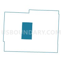
Outline

Summary
| Unique Area Identifier | 608873 |
| Name | Centerview Voting District |
| County | Johnson County |
| State | Missouri |
| Area (square miles) | 62.63 |
| Land Area (square miles) | 62.46 |
| Water Area (square miles) | 0.17 |
| % of Land Area | 99.72 |
| % of Water Area | 0.28 |
| Latitude of the Internal Point | 38.74765730 |
| Longtitude of the Internal Point | -93.86301020 |
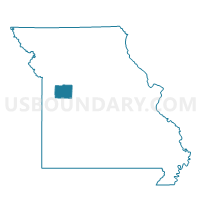
Maps

Graphs
Select a template below for downloading or customizing gragh for Centerview Voting District, Johnson County, Missouri


Neighbors
Neighoring Voting District (by Name) Neighboring Voting District on the Map
- Chilhowee Voting District, Johnson County, MO
- Columbus Voting District, Johnson County, MO
- Hazel Hill Voting District, Johnson County, MO
- North Holden Voting District, Johnson County, MO
- South Holden Voting District, Johnson County, MO
- Warrensburg Northwest Voting District, Johnson County, MO
- Warrensburg Southwest Voting District, Johnson County, MO
Top 10 Neighboring County Subdivision (by Population) Neighboring County Subdivision on the Map
- Warrensburg township, Johnson County, MO (23,218)
- Madison township, Johnson County, MO (3,277)
- Hazel Hill township, Johnson County, MO (1,824)
- Centerview township, Johnson County, MO (1,594)
- Chilhowee township, Johnson County, MO (1,140)
- Columbus township, Johnson County, MO (1,124)
Top 10 Neighboring Place (by Population) Neighboring Place on the Map
Top 10 Neighboring Unified School District (by Population) Neighboring Unified School District on the Map
- Warrensburg R-VI School District, MO (25,863)
- Holden R-III School District, MO (8,613)
- Johnson County R-VII School District, MO (3,630)
- Chilhowee R-IV School District, MO (1,053)
Top 10 Neighboring State Legislative District Lower Chamber (by Population) Neighboring State Legislative District Lower Chamber on the Map
- State House District 122, MO (40,384)
- State House District 121, MO (37,199)
- State House District 120, MO (35,276)
Top 10 Neighboring State Legislative District Upper Chamber (by Population) Neighboring State Legislative District Upper Chamber on the Map
Top 10 Neighboring 111th Congressional District (by Population) Neighboring 111th Congressional District on the Map
Top 10 Neighboring Census Tract (by Population) Neighboring Census Tract on the Map
- Census Tract 9603, Johnson County, MO (8,910)
- Census Tract 9601, Johnson County, MO (8,677)
- Census Tract 9602, Johnson County, MO (5,193)
- Census Tract 9609, Johnson County, MO (4,939)